Go to main content

Earthquake Report

Earthquake Report Map

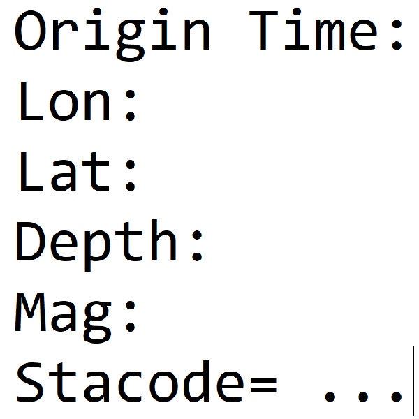
Earthquake Report No.001

  • Origin Time: 2026/01/04 03:52:50
  • Epicenter: 24.7°N, 121.76°E 3.4 km S of Yilan County Hall
  • Focal depth: 8.8 km
  • Magnitude (ML): 4.4

Intensity

Neicheng 4 Dongshan 4 Yilan City 3 Toucheng 3 Niudou 3 Nan-ao 3 Guishandao 2 Nanshan 2 Su-ao 2 Datong 1
Xizhi 3 Shuangxi 2 Xindian 2 Wufenshan 2 Wulai 2 Sandiaojiao 1 New Taipei City 1 Sanxia 1 Wanli 1 Tamsui 1
Sanguang 2 Daxi 1 Taoyuan City 1 Xinwu 1
Xinyi District 2 Muzha 1 Taipei City 1
Heping 2 Taroko 2 Xibao 1

Remarks

Note
Origin Time The origin time of earthquake in terms of Taiwan time
Lat Latitude of earthquake (°N)
Lon Longitude of earthquake (°E)
Depth Focal depth of earthquake in km
Mag The local magnitude (ML)
Stacode Station's code
Staname Station's name
Stalat Latitude of station (°N)
Stalon Longitude of station (°E)
Dist Epicentral distance in km
BAZ Azimuth in degree
PGA Peak ground acceleration of three components (VNE) in cm/s2
PGV Peak ground velocity of three components (VNE) in cm/s
Int Taiwan intensity scale (Level 0, 1, 2, 3, 4, 5-, 5+, 6-, 6+, 7)
PGA(SUM) Peak ground acceleration (Vector sum) in cm/s2
PGV(SUM) Peak ground velocity (Vector sum) in cm/s