Timing of typhoon product releases
- Typhoon information must be aligned with the international meteorological observation schedule (02, 08, 14, and 20 UTC daily). After undergoing data collection, analysis, and interpretation, approximately 1.5 to 2 hours of processing time is required before it can be issued.

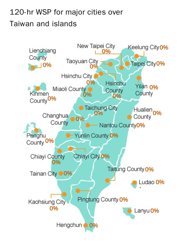
Why is a typhoon wind speed probabilities (hereafter WSP) product necessary?
- Since typhoon forecasts cannot achieve 100% accuracy, it is essential to provide WSP as reference for decision-making. Different industries require varying response times and levels of preparedness when facing a typhoon. Based on different risk management considerations, decision-makers can activate phased preventive measures according to changes in probability. This approach aligns with practices in advanced countries worldwide. It is important to note, however, that WSP does not directly or indirectly indicate the following: the probability of the typhoon’s center making landfall, the magnitude of potential typhoon-related disasters, the probability of such disasters occurring, or the timing of the issuance of typhoon warnings by the CWA.
When and how often are typhoon analysis and forecast products released? Also, why aren’t the 8:00 AM typhoon analysis and forecast issued exactly at 8:00 AM?
- Whenever a typhoon or tropical depression develops in the Western North Pacific Ocean or the South China Sea, our typhoon analysis and forecast products are made available on the CWA’s official webpage, with updates every six hours. Once such weather systems dissipate, these products are no longer provided.
- Typhoon analysis and forecast follow international meteorological observation times (02:00, 08:00, 14:00, and 20:00 UTC daily). After we collect the observation data, our forecasters analyze, interpret, and edit the products. This process typically takes about 1.5 to 2 hours, which is why the 8:00 AM analysis and forecast products are not published exactly at 8:00 AM.
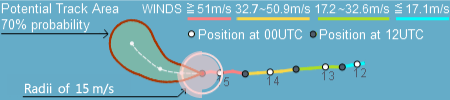
What does typhoon potential track area (hereafter PTA) mean?
- PTA represents a domain that a typhoon/tropical storm center will likely move in at a specific time, which implies track forecast uncertainties, based on the CWA official track error statistics in the past five years. These yellow shaded areas do not refer to the typhoon/tropical storm radius, rather, a circle of 70% probability that the storm center is entering within.
What are the major factors affecting the size of the PTA?
- Size of the PTA circle is primarily related to the forecast period. However, it is also affected by the storm's moving speed and direction. The PTA circle is typically larger if a typhoon/tropical storm is expected to move faster or undergo recurvature.


Why is a typhoon wind speed probabilities (hereafter WSP) product necessary?
- Since typhoon forecasts cannot achieve 100% accuracy, it is essential to provide WSP as reference for decision-making. Different industries require varying response times and levels of preparedness when facing a typhoon. Based on different risk management considerations, decision-makers can activate phased preventive measures according to changes in probability. This approach aligns with practices in advanced countries worldwide. It is important to note, however, that WSP does not directly or indirectly indicate the following: the probability of the typhoon’s center making landfall, the magnitude of potential typhoon-related disasters, the probability of such disasters occurring, or the timing of the issuance of typhoon warnings by the CWA.
When and how often are typhoon analysis and forecast products released? Also, why aren’t the 8:00 AM typhoon analysis and forecast issued exactly at 8:00 AM?
- Whenever a typhoon or tropical depression develops in the Western North Pacific Ocean or the South China Sea, our typhoon analysis and forecast products are made available on the CWA’s official webpage, with updates every six hours. Once such weather systems dissipate, these products are no longer provided.
- Typhoon analysis and forecast follow international meteorological observation times (02:00, 08:00, 14:00, and 20:00 UTC daily). After we collect the observation data, our forecasters analyze, interpret, and edit the products. This process typically takes about 1.5 to 2 hours, which is why the 8:00 AM analysis and forecast products are not published exactly at 8:00 AM.
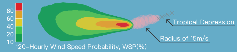
What does the WSP indicate?
- The WSP is a measure of how likely it is that a certain event will occur. For example, WSP 80% indicates that 80 times out of 100 forecasts that the storm radius of 30 kt winds passes through a given location, based on 100 similar track forecasts issued by the CWA in the past five years.
Does a higher WSP value mean stronger winds and heavier rain?
- As a typhoon approaches, the probability value generally increases, indicating a higher likelihood of stronger winds and heavier rain. However, due to the asymmetric structure of typhoons and the influence of terrain, the intensity of winds and rain can vary across different locations. Therefore, the probability value alone cannot fully determine the extent of wind and rain. For accurate forecasts on wind and rain intensity, it is strongly recommended to refer to typhoon warning bulletin and weather warnings issued by the CWA.
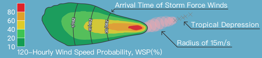
What is the difference between the 6h-WSP-6h and the 120h-WSP?
- According to the characteristics calculated from probability values, the individual 6-hour probabilities will not exceed the 120-hour probabilities, and the cumulative 6-hour probabilities for 120 hours will not be equal to the single 120-hour probabilities; just like that, for example, if the probability of precipitation (POP) for the daytime is 60% and the nighttime 60%, the POP for the whole day can not be 120% (greater than 100%).
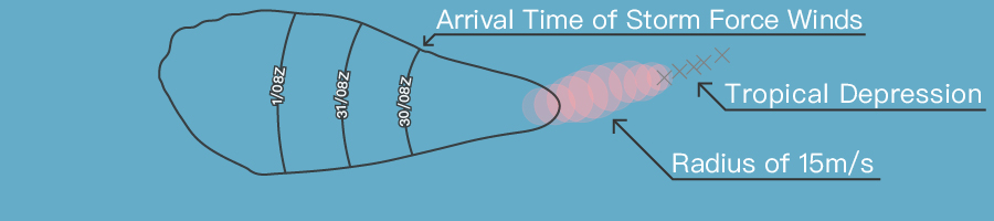
How are “Most Likely Arrival Time” and “Earliest Reasonable Arrival Time of storm-force winds” determined?
- This product utilizes the CWA's official forecast error statistics, arranging the actual potential arrival times from slowest to fastest. It then selects the 50th percentile (with 50% of the time points on either side, indicating a median speed) and the 90th percentile (with 90% of the time points slower than this value, indicating a faster speed). These are designated as the "Most Likely Arrival Time" and "Earliest Reasonable Arrival Time," respectively. It is recommended that vulnerable groups complete disaster preparedness work before the earliest reasonable arrival time.
Why should the “120-hour WSP” and the ”Most Likely/Earliest Reasonable Arrival Time of storm-force winds” be presented on the same map ?
- The information on Most Likely/Earliest Reasonable Arrival Time of storm-force winds is recommended to be interpreted together with the storm impact probability (shaded). If the arrival time information is considered alone without taking into account the WSP, it may mistakenly suggest that the storm will definitely arrive at that time, leading to an "overestimation" of the risk of storm impact.
How should the "Most Likely Arrival Time” and the “Earliest Reasonable Arrival Time of storm-force winds”be applied, and what precautions should be taken?
- This product can be used as an early warning reference 3 to 5 days before the typhoon approaches, aimed at groups with higher risk management needs and moderate to low risk tolerance. It is recommended to complete disaster preparedness measures before the Most Likely/Earliest Reasonable Arrival Time of storm-force winds conditions. It is important to note that this product is not suitable for scenarios where the typhoon track forecast is highly uncertain, such as in slow-moving, stationary, or circling situations. Additionally, for accurate forecasts on wind and rain intensity within 24 hours, it is strongly recommended to refer to the typhoon warning bulletin and weather warnings issued by the CWA.